8th Jan Snow Conditions: Gulmarg, Pahalgam, Manali, Keylong
Storm Overview: A Mixed Bag
The storm that arrived on January 4th and 5th carried a lot of promise on paper. A week before it hit, forecasts showed it could be a big one—potentially delivering a meter of snow. IMD meteograms looked strong, and the GFS ensemble models gave us hope. There was excitement in the air...
People were keen to move up the mountains. Travel arrangements and logistics were being worked out.
What actually happened? Not so much. In most regions, it was lackluster, leaving us with a patchy story of snow distribution and very different impacts depending on where you were.
Region-wise Breakdown
1. Kashmir (Gulmarg and Surroundings)
Snowfall and Skiing Conditions:
Gulmarg saw around 30-35 cm of accumulation, with wind effects creating some variability in areas especially in the alpine.
Skiing wise the snow on the face value was fantastic. The cold temperatures meant the snow on the top layer was dry and light -- even down to treeline and below.
But here’s the catch: the snowpack is shallow, sitting at just 80 cm at 3200 meters.
The Snowpack Story:
Brian Newman, the snow safety officer in Gulmarg, provided some fascinating insights into what’s happening under the surface.
“There’s a persistent weak layer of faceted snow from late November at the base—about eight inches thick,” he explained. “The real kicker is a strong melt-freeze crust sitting on top of that weak layer, acting like a bridge. It holds the load of the snow above it, stopping the weak layer from collapsing naturally.”
What does this mean? According to Brian, “It takes about four skier loads to break that crust.” In other words, "for a natural avalanche to flush out the weak layer, we’d need more snow than what would have been sufficient, had the crust not been present."
This crust is going to make things tricky in the backcountry this season. It’s a hidden enemy, especially in shallow snowpacks like the one we currently have in Gulmarg.
FOR DAILY AVALANCHE BULLETIN VISIT
GULMARG AVALANCHE CENTER
Avalanche Mitigation:

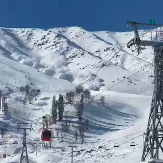
Yesterday, the Gulmarg ski patrol carried out avalanche control in the gondola bowls. The main bowl saw large results including a D4 avalanche.
Results were also observed in the South Bowl on either of the flanking faces. Sympathetic releases were also observed.
Backcountry conditions remain dangerous, with cracks visible on the fresh snow layer.
__________________________________________
A note from Pahalgam
After the storm, another area had this profile (sans the melt freeze crust)
________________________________________________
2. Manali and Sethan Region
Manali and Upper Kullu Valley:
The storm barely made an impression here, delivering just a few centimeters of snow. Overall, it was a no-show.
Sethan:
Reports suggest the snowpack is about 40-50 cm deep at 3200m—half of what Gulmarg is seeing. We’re still waiting on detailed assessments of the snow structure, but updates should start coming in over the next few days.
_______________________________________________
3. Lahaul (Kelong and Seven Sisters Slopes)
Snowfall in this region was negligible, with just a couple of centimeters observed. So far, there are no reports of significant crust development or faceting, but more observations are needed.
Snowpack depth is 20cm in mid mountain on the the Seven sister slopes. Areas above Puker Village show, about 30+ cm of snow.
Gondala
Across Gondala, on the LB of Chandra River.
This primarily north aspect looks well covered. Although the snowpack is shallow and potentially rotting into facets each day. When loaded with new snow, it will create very dangerous backcountry conditions.
_______________________________________________
How does the weather look going forward?
A feeble western disturbance will hit around 11th Jan.
The impact seems to be hardly worth getting excited.
But with how the end Dec took us all by surprise, I won't be writing it off.
Further into early 3rd week Jan, something serious is potentially coming in.
Key questions to consider for snowpack going into 2nd week Jan
1. How will the rate of faceting occur on the latest storm layer.
2. How will the old snow layers change during this period?
3. How will the new snow surface change during this period: will we se surface hoar development or crust development or what other type of recrystallisation depending on the altitude, aspect and localized weather


Is the weak layer in Gulmarg present across all aspects?
ReplyDeleteIn alpine zones yes it should be widespread.
DeleteSouth facing aspects will have higher likelihood of having that stubborn crust topping the depth hoar layer.